Thasos
83 km away
Thasos is the northernmost large Greek island, a round, green mountain of marble and pine forest just off the coast of…
17 tours & trips
Greece · Aegean Sea · Nature & wildlife island
Samothrace is a rugged island of 178 square kilometres in the far north of the Aegean, two hours by ferry from Alexandroupoli, rising to 1,611 metres at Mount Fengari. It is a place for walkers and swimmers in rock pools rather than for beach resorts, and it holds the Sanctuary of the Great Gods, where the Winged Victory now in the Louvre was found.
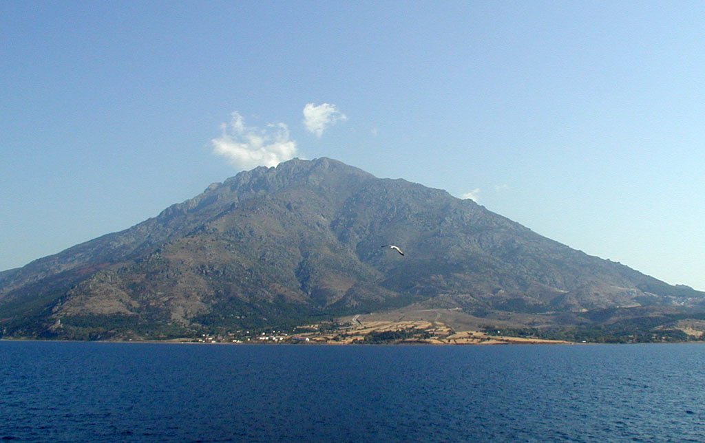
Photo: No machine-readable author provided. Marsyas assumed (based , CC BY-SA 3.0
| Getting there | Ferry from Alexandroupoli about 2 h, daily all year and more often in summer; no airport |
|---|---|
| Gateway | Alexandroupoli (ferry) |
| Travel time | About 2 h by ferry |
| Days | 3 to 5 nights |
| Best months | Jun–Sep for swimming; May–Jun and Sep for hiking and the waterfalls |
| Getting around | Rent a car or scooter; a few buses run along the north and west coasts |
| Booking | Ferries with a car and rooms ahead for late July and August; little else |
| Cost | Cheap for a Greek island |
| Beaches | Mostly pebbles; Pachia Ammos is the sandy one in the south, Kipos a long pebble beach in the east |
| Sea | Aegean Sea |
| Archipelago | North Aegean Islands |
| Area | 178 km² |
| Population | 2,596 (2021) |
| Highest point | 1,611 m (Fengari) |
| Ferry | 2 h from Alexandroupoli (ferry) |
| Airport | No |
| Car-free | No |
| Checked | October 2026 |
Nothing is sold online for Samothrace on its own, and the island is not set up for organised tours. Visitors come independently on the ferry from Alexandroupoli, usually with a car or a plan to rent one, and spend their days walking, swimming in river pools and visiting the ancient sanctuary.
What you can arrange locally is limited but useful. In summer small boats leave the south coast for trips along the cliffs to Vatos beach and the Kremasto waterfall, which drops straight into the sea; these coves cannot be reached by road, and the trip usually includes swimming stops. A few local guides lead hikes up Fengari or through the gorges, which is worth it if you are not an experienced walker, as trails are poorly marked. Car and scooter hire is available at the port and in Therma, and should be reserved in August.
The archaeological site and its museum at Palaiopoli can be visited on your own with a ticket, and the signs explain the main buildings well.
The plain recommendation is to come for three or four nights with a car, spend a day at the sanctuary and Chora, a day walking up the Fonias gorge to the waterfalls, a day on the south coast with the boat trip, and, if you are fit, a dawn start for the summit.
At Palaiopoli on the north coast, about 6 km east of the port, the ruins of the sanctuary spread over a wooded slope by a stream, with columns, the circular rotunda and the theatre site. Here initiates were admitted to mysteries for centuries. The museum holds a plaster copy of the Winged Victory and original finds from the site. Allow two hours.
East of Therma, a path follows the Fonias river upstream through plane trees to a series of waterfalls and deep green pools, called vathres. The first large pool is about 45 minutes' walk from the road; the path then becomes rougher. Swim in cold, clear water, wear good shoes, and avoid the gorge after heavy rain.
The island's capital sits in a hollow in the hills above the port, out of sight of the sea, as a defence against pirates. Its stone houses with red tiled roofs climb to the remains of a Genoese castle. Walk the narrow lanes, sit in the square under the plane trees for coffee, and look out from the castle over the north coast.
Therma, on the north coast, is a green village of plane trees, streams and hot springs with small bathhouses, popular with campers and walkers. From here, a steep trail climbs to Fengari, the summit of the island at 1,611 metres, with views to Turkey and Mount Athos on clear days. It takes about five hours up; go only in settled weather.
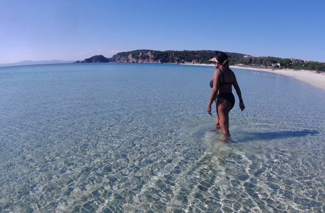
The road along the south coast passes through olive groves and the village of Lakkoma to Pachia Ammos, the island's only long sandy beach, with a taverna and clear water. On the way, look out over the cliffs, and in summer take a boat from here to Vatos and Kremasto. Kipos beach in the east has dark pebbles and views to Turkey.
Samothrace has no airport, and the only regular way in is by ferry from Alexandroupoli, on the mainland coast of Thrace. Ferries take about two hours and run every day all year, several times a day in summer, landing at Kamariotissa on the west coast. Book ahead in July and August, especially with a car, as capacity is limited and the island fills with Greek visitors in mid-August. In winter, crossings are sometimes cancelled in strong winds.
Alexandroupoli has an airport with flights of about an hour from Athens, and it is a few hours by road from Thessaloniki. Some summers also see occasional ferry links with Kavala or Lemnos; check locally. Taking a car is worth it if you plan to explore beyond the north coast, otherwise rent on the island.
A car or scooter is almost essential, as distances are longer than they look and the mountain blocks the middle of the island. A paved road runs along the north and west coasts from Kamariotissa to Therma and Kipos, and another crosses to the south coast and Pachia Ammos, but there is no road around the south-east. Buses connect the port with Chora, Therma and Palaiopoli a few times a day in summer. Taxis are few. Watch for goats on the roads.
Samothrace has a short season. July and August are the warmest months, with sea temperatures in the low to mid 20s and lively village life; mid-August is the busiest time, with the island full of Greek families and young campers, and higher prices. The north wind can be strong in summer, making the north coast choppy.
May, June and September are the best months for walking, with green slopes, flowing waterfalls in spring and fewer people, and the sea is warm enough to swim from June. Late spring is ideal for the summit climb. From October to April most hotels, tavernas and the boat trips close, the weather is wet and windy, and ferries are fewer; only a few places stay open in Chora and Kamariotissa. Three to five nights let you hike, swim and see the sanctuary without hurrying.
Kamariotissa, the port, has the most rooms, shops and tavernas and is handy for ferries, but it is the least attractive base. Chora is the most charming village, cool in summer and central for the north and south coasts. Therma suits walkers and those who want greenery, hot springs and access to the gorges. Lakkoma and Profitis Ilias give a quiet village stay closer to the south coast.
Samothrace never had a natural harbour or fertile plains, so it became important not through trade but through religion. Thracian settlers worshipped the Great Gods here, and from the seventh century BC the sanctuary drew initiates from all over the Greek world; Philip II of Macedon is said to have met Olympias, the mother of Alexander, at the mysteries. The Winged Victory, made around 190 BC, was found there in 1863 and taken to Paris. Later came Byzantine, Genoese and Ottoman rule, and the island joined Greece in 1912.
Samothrace pairs best with Alexandroupoli, the gateway town, and the Evros delta wetlands nearby for birdwatching. Thassos is the obvious island to combine it with, reached via Kavala by road and ferry. Lemnos is further south in the North Aegean, and Thessaloniki is about four hours from Alexandroupoli by road.
83 km away
Thasos is the northernmost large Greek island, a round, green mountain of marble and pine forest just off the coast of…
17 tours & trips
142 km away
Ammouliani is the only inhabited island of Halkidiki, a low, sandy island of about 4.5 square kilometres in the gulf…
17 tours & trips
150 km away
Lesbos is Greece's third largest island, a big, green slice of the north-east Aegean only a few kilometres off the…
5 tours & trips
Ferry from Alexandroupoli about 2 h, daily all year and more often in summer; no airport.
From Alexandroupoli (ferry): about 2 h by ferry.
3 to 5 nights.
Jun–Sep for swimming; May–Jun and Sep for hiking and the waterfalls.
Rent a car or scooter; a few buses run along the north and west coasts.
Go if you want mountain walks, river gorges with waterfalls and cold pools, an ancient sanctuary and a cheap, unpolished island. Skip it or choose Thassos if you want long sandy beaches, resort hotels and easy ferries. At about 2 h each way from Alexandroupoli (ferry), it is worth staying at least one night.
Cheap for a Greek island.
Mostly pebbles; Pachia Ammos is the sandy one in the south, Kipos a long pebble beach in the east.
Ferries with a car and rooms ahead for late July and August; little else.
North Aegean Islands, Greece
Samos is a green, mountainous Greek island in the eastern Aegean, separated from the Turkish coast by a strait only 1.6…
29 tours & trips
North Aegean Islands, Greece
Chios is the fifth-largest Greek island, 842 square kilometres in the northeast Aegean just 7 km from the Turkish…
20 tours & trips
North Aegean Islands, Greece
Lesbos is Greece's third largest island, a big, green slice of the north-east Aegean only a few kilometres off the…
5 tours & trips
North Aegean Islands, Greece
Ikaria is a mountainous island in the eastern Aegean, about 19 km south-west of Samos, known for the long, healthy…
2 tours & trips
North Aegean Islands, Greece
Lemnos is the eighth-largest Greek island, a flat, golden landscape of volcanic hills, vineyards and sand dunes in the…
No tours listed