Nami Island
295 km away
Nami Island is a small, half-moon river island in the Bukhan River, about 60 km north-east of Seoul, planted with long…
31 tours & trips
South Korea · Seas of Japan & Korea · Nature & wildlife island
Ulleungdo is a steep volcanic island in the East Sea, about 120 km off South Korea's east coast, rising to 984 metres at Seonginbong. Known for coastal walking trails, sea stacks, drying squid and mountain herbs, it is a popular Korean getaway reached by ferries of around three hours from Pohang and other mainland ports.
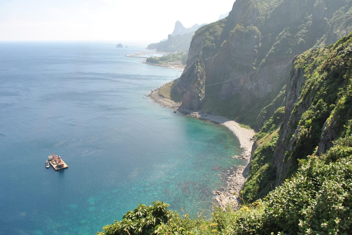
Photo: Korea.net / Korean Culture and Information Service, CC BY-SA 2.0
| Getting there | Ferries from Pohang, Gangneung, Mukho and Hupo in roughly 3 to 4 h; often cancelled in rough seas |
|---|---|
| Gateway | Pohang (also Gangneung, Mukho, Hupo) |
| Travel time | About 3 to 4 h by ferry |
| Days | 1 to 2 nights |
| Best months | May–Oct; Jul–Aug busiest; winter seas often cancel ferries |
| Getting around | Buses around the ring road, taxis or a hired car; the island is too steep for casual cycling |
| Booking | Ferries and rooms weeks ahead for summer and holidays; keep a spare day for cancellations |
| Cost | Mid-range by Korean standards; food a little dearer |
| Beaches | Pebble and rock coves only; swim at small coves and rock pools in summer |
| Sea | Seas of Japan & Korea |
| Area | 73 km² |
| Population | 10,426 (2023) |
| Highest point | 984 m (Seonginbong) |
| Airport | No |
| Car-free | No |
| Checked | October 2026 |
Nothing for Ulleungdo is sold on the big international booking sites. Most Korean visitors come on packages from mainland travel agencies that combine the ferry, a guesthouse and island bus tours, while independent travellers book the ferry themselves and arrange the rest locally.
The most common local product is the bus tour. Two standard loops, sold at the ferry terminals and by guesthouses, cover the northern and southern halves of the island in a few hours each, stopping at viewpoints, rock formations and villages, with a Korean-speaking driver. They are cheap and efficient if you do not mind a group.
The second is a boat trip around the island, about two hours along cliffs and sea stacks, with a separate short boat to the islet of Jukdo. The third is the trip to Dokdo, the remote rocks about 87 km to the southeast; boats run in calm weather, and landing is allowed only when the sea permits, which is far from every trip.
Hiking needs no tour: the trail to Seonginbong and the coastal walks are well marked. For a short stay, a bus loop on day one and a walk plus a boat on day two works well.
From the ferry port of Dodong, a walkway clings to the cliffs above the sea, crossing bridges, ducking through rock tunnels and climbing spiral stairs to the Haengnam lighthouse. The water below is startlingly clear. The walk takes one to two hours and can close after storms, so check at the tourist office first.
The island's highest peak, 984 metres, is a steep half-day climb through old forest from Dodong or a gentler descent to the Nari Basin, a flat volcanic crater on the north side and the only farmland on the island. Traditional log houses stand in the basin, and the herbs and potatoes grown there end up in local dishes.
A sightseeing boat circles Ulleungdo in about two hours, passing basalt columns, natural arches and sea stacks such as Kokkiri, the elephant rock that seems to drink from the sea. Sit on the side facing the cliffs. The boat also gives the best sense of how sheer the island is, with villages squeezed into narrow valleys.
On the northwest coast, a monorail climbs from the village of Taeha to a lighthouse, and a short walk leads to Daepunggam, a cliff-top viewpoint over a stretch of coastline often voted one of the finest in Korea. Allow two hours, and combine it with a stop at Hyeonpo, the old port nearby, on the round-island bus.
A footbridge links the main island with the small grassy islet of Gwaneumdo, where a loop path passes cliff-top views across to Jukdo and the Samseonam rocks. The surrounding coast is quiet, with a few seafood restaurants. On the way, look out for squid hung on racks to dry in the sun, a classic Ulleungdo sight.
A boat of about one and a half to two hours each way runs to Dokdo, a pair of volcanic rocks to the southeast that are a symbol of national pride for Koreans and are also claimed by Japan. Landing for a short visit is possible only in calm seas. Bring your passport, required for the trip.
Ulleungdo has no airport, so every visitor comes by sea. Ferries run from Pohang, the main gateway, and also from Gangneung, Mukho near Donghae and Hupo near Uljin, taking roughly three to four hours depending on the route and vessel; a larger overnight car ferry also sails from Pohang. Boats arrive at Dodong or the newer port at Sadong.
Pohang is reached by KTX train from Seoul in about two and a half hours, Gangneung in under two hours. Book tickets ahead for weekends, summer and holidays, and expect cancellations when waves are high, especially from November to March. Always leave a spare day before an international flight, and take seasickness tablets.
The ring road around Ulleungdo was completed only recently and is narrow, winding and steep, with long tunnels. Local buses follow it around the island roughly every half hour to hour, linking Dodong, Sadong, Jeodong, Taeha and Cheonbu, with a branch to the Nari Basin. Taxis, many of them four-wheel-drive, can be hired for the day, and car rental is available but parking is tight in Dodong. Walking between villages is not practical, but trails link the main sights.
Ulleungdo is a warm-season destination. From May to October ferries run most reliably and the trails are open; May and June are fresh and green with wild herbs, while July and August are hot and humid and the busiest, with Korean summer holidays filling ferries and guesthouses. Typhoons can disrupt travel in August and September.
Autumn, from late September to October, brings clear air, colourful forest on the slopes and the end of the squid season, when fishing boats light up the sea at night. Winter is cold, windy and very snowy, among the snowiest places in Korea, and many ferries are cancelled for days at a time. One or two nights covers the highlights; add a day for Dokdo or the summit.
Dodong, the main port, has the most guesthouses, motels and restaurants, close to the ferry, the coastal trail and the Dokdo boats, though it is crowded and squeezed into a narrow valley. Jeodong, a short bus ride north, is a quieter fishing port with good seafood. Sadong, near the newer port, has a few larger hotels. On the north coast, pensions around Cheonbu and Hyeonpo suit those wanting peace and sunset views.
People lived on Ulleungdo from the 1st millennium BC, and it was the seat of the small kingdom of Usan until a general of the Silla kingdom conquered it in 512. Under the Joseon dynasty the island was deliberately emptied for centuries to deter pirates, and only resettled in the 1880s. European sailors knew it as Dagelet Island after a French expedition of 1787. Fishing, especially for squid, shaped the modern island, and tourism has grown since the ring road and new ports opened.
Combine Ulleungdo with Pohang, where the sunrise point at Homigot and the seafood market fill a day, or with Gyeongju, the old Silla capital, about 30 minutes from Pohang by train. From Gangneung, the east coast beaches and Seoraksan National Park are within two hours. Dokdo is a day trip from the island in calm weather.
295 km away
Nami Island is a small, half-moon river island in the Bukhan River, about 60 km north-east of Seoul, planted with long…
31 tours & trips
390 km away
Ganghwa is a large island at the mouth of the Han River, joined by bridges to the mainland about 60 km north-west of…
4 tours & trips
Ferries from Pohang, Gangneung, Mukho and Hupo in roughly 3 to 4 h; often cancelled in rough seas.
From Pohang (also Gangneung, Mukho, Hupo): about 3 to 4 h by ferry.
1 to 2 nights.
May–Oct; Jul–Aug busiest; winter seas often cancel ferries.
Buses around the ring road, taxis or a hired car; the island is too steep for casual cycling.
Go if you like dramatic coastal walks, mountain hikes, seafood and a corner of Korea few foreigners reach. Skip it or choose Jeju if you want beaches, reliable access in winter or an easy trip without the risk of rough seas.
Mid-range by Korean standards; food a little dearer.
Pebble and rock coves only; swim at small coves and rock pools in summer.
Ferries and rooms weeks ahead for summer and holidays; keep a spare day for cancellations.
South Korea
Jeju is South Korea's largest island, an oval volcano about 73 km long lying some 80 km off the southern tip of…
118 tours & trips
South Korea
Nami Island is a small, half-moon river island in the Bukhan River, about 60 km north-east of Seoul, planted with long…
31 tours & trips
South Korea
Ganghwa is a large island at the mouth of the Han River, joined by bridges to the mainland about 60 km north-west of…
4 tours & trips