Oahu
Hawaiian Islands, United States
Oahu is the third-largest of the Hawaiian Islands and home to about a million people, two thirds of the state's…
331 tours & trips
United States · Pacific Ocean · Nature & wildlife island
Kauai is the oldest and greenest of the main Hawaiian Islands, a 1,456-square-kilometre volcanic dome cut by Waimea Canyon and walled on the north-west by the sea cliffs of the Na Pali Coast. It has no high-rise hotels, a road that cannot circle the island and some of the best hiking and boat trips in Hawaii.
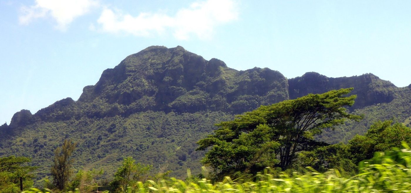
Photo: Thank You (23 Millions+) views, CC BY 2.0
| Getting there | Flights of about 35 minutes from Honolulu to Lihue; direct flights from the US West Coast; no inter-island ferry |
|---|---|
| Gateway | Lihue airport, via Honolulu |
| Travel time | About 35 min by air from Honolulu |
| Days | A week or more |
| Best months | Apr–Oct drier and calmer; Nov–Mar wetter with big north-shore surf |
| Getting around | Rent a car; the coastal highway runs from Ke'e Beach round to Polihale but never meets |
| Booking | Haena park entry, Na Pali boat trips and helicopter flights weeks ahead; cars early |
| Cost | Expensive, even by Hawaiian standards |
| Beaches | Golden sand: Poipu and Tunnels for snorkelling, Hanalei Bay for the setting, Polihale for space |
| Sea | Pacific Ocean |
| Archipelago | Hawaiian Islands |
| Area | 1,456 km² |
| Population | 73,298 (2020) |
| Highest point | 1,598 m (Kawaikini) |
| Airport | Yes, scheduled flights |
| Car-free | No |
| Checked | October 2026 |
Kauai sells far more than its size suggests, and the offer splits into sea, air and land.
The Na Pali Coast is the main event, and since no road reaches it, a boat is the easy way to see it. Catamarans leave Port Allen on the south-west coast for half-day or full-day sails with snorkelling, breakfast or lunch and drinks; summer sunset sailings with dinner are popular. Rafts are smaller, faster and go into sea caves when the swell allows. Some longer trips cross to snorkel off Niihau, the private island to the west.
Helicopter flights from Lihue or Princeville cover the canyon, the Na Pali valleys and the crater of Waialeale in under an hour. Doors-off versions are for photographers.
On land you will find guided days to Waimea Canyon, kayak trips up the Wailua River with a walk to a waterfall, film-location tours, food tours, ziplines and luaus with dinner and a show. Day trips from Oahu by plane exist, but they leave little time on the ground.
Most visitors rent a car and do the canyon and the beaches on their own, then book two things: a Na Pali boat trip and, if the budget allows, a helicopter flight.
Some 25 km of fluted green cliffs up to about 1,200 metres high, with hanging valleys and sea caves, on the roadless north-west shore. See it from a boat out of Port Allen or walk the first part of the Kalalau Trail from Ke'e Beach to Hanakapiai Beach, a hard 3 km each way. Going further needs a camping permit.
A canyon about 16 km long and up to 1,000 metres deep, red and green rock eroded into the west side of the island. Drive up from Waimea town, stopping at the canyon lookouts, then continue into Kokee State Park to the Kalalau and Puu O Kila lookouts, where the road ends above the Na Pali valleys. Allow a full day.
Cross the one-lane bridge into Hanalei, a small town of surf shops and cafes behind a wide bay backed by mountains and waterfalls. Beyond it the road passes Lumahai, Tunnels and Haena beaches before ending at Ke'e. In summer the water is calm and clear for snorkelling; in winter big swells make it dangerous.
The Wailua is one of the few navigable rivers in Hawaii. Paddle a kayak upstream and walk through the forest to a waterfall, or take the riverboat to the Fern Grotto. Nearby, Opaekaa and Wailua falls are easy roadside stops, and Kapaa, a few minutes north, has the best choice of food trucks and casual places.
The sunniest part of the island, with protected beaches, snorkelling and resorts. Hawaiian monk seals and green turtles often haul out on the sand, so keep your distance. Spouting Horn blowhole is a short drive west, and the two tropical gardens at Lawai, Allerton and McBryde, are visited from here by guided tour or day pass.
At the far western end, past Kekaha and the military range, a rough unpaved track leads to Polihale, a beach of about 11 km of sand under the last Na Pali cliffs. It is wild, sunny and almost empty, but has no lifeguards and strong currents. Check that your rental terms allow the dirt road and bring all your water.
Our pick for each kind of trip, with live dates and prices. Free cancellation on most.
Best for: First visit, the Na Pali Coast by sea
A catamaran sail from Port Allen along the roadless cliffs, with a snorkel stop and food on board; the single trip most visitors remember from Kauai.
Almost everyone arrives by air at Lihue airport on the east coast. Inter-island flights from Honolulu take about 35 minutes and run many times a day; there are also flights from Maui and the Big Island, and direct services from several West Coast cities, among them Los Angeles, San Francisco and Seattle. Flying from Europe or Asia means a connection in Honolulu or on the mainland.
There is no passenger ferry between the Hawaiian islands, so you cannot bring a car from Oahu. Pick up a rental car at the airport, booked well ahead because the island fleet is limited and sells out in holiday periods.
Cruise ships on Hawaiian itineraries dock at Nawiliwili Harbour, a short drive from Lihue, usually for a single day.
A car is close to essential. The main highway follows the coast from Ke'e Beach in the north round the east and south to Polihale in the west; the Na Pali cliffs block the gap, so north shore to canyon is a three-hour drive. The Kauai Bus links the main towns on weekdays and less often at weekends, but does not reach the trailheads or the canyon. Traffic around Kapaa and Lihue is slow at rush hours. Bikes suit the coastal path at Kapaa.
Kauai is warm all year, with air around 25 to 30 degrees and sea temperatures from about 24 degrees in winter to 27 in late summer. Rain is the variable. The north and east catch the trade winds and get far more of it than the dry south and west, and the summit of Waialeale is one of the wettest places on earth.
April to October is the drier half: the north shore sea is calm, Na Pali boat trips and snorkelling are at their best, and the Kalalau Trail is safer. From November to March storms bring heavy rain, flash floods and huge surf on the north shore, which closes beaches and some boat routes; the south shore stays sunnier. Humpback whales pass from December to April.
Prices peak at Christmas, in spring holidays and in July and August. Give the island a week: it is slow to drive and the weather may force you to swap days.
Most visitors split their stay or choose by season. Poipu on the south shore is the sunniest base, with resorts, condos and calm beaches, and it is closest to Waimea Canyon. Princeville and Hanalei on the north shore are greener and more beautiful but wetter, best from April to October and handy for Na Pali hikes. The east side between Lihue and Kapaa is the central and cheaper option, with the most restaurants and easy reach of both ends.
Kauai is the oldest of the main islands, built by a shield volcano some five million years ago and worn down by rain into canyons and cliffs. Polynesian voyagers settled it early and farmed taro in its valleys; terraces survive in places. Captain Cook made his first Hawaiian landing at Waimea in 1778. Kauai was the only island Kamehameha never conquered: its chief Kaumualii accepted his rule by agreement in 1810. Sugar shaped the next century, starting at Koloa in 1835. Today a rule that no building rise above the palm trees keeps the coast low.
Kauai pairs naturally with Oahu: a few days in Honolulu and Waikiki, with Pearl Harbor, then a 35-minute flight to Lihue. Many visitors add Maui or the Big Island for the volcano, each reached by a short inter-island flight, often via Honolulu. Niihau, the private island just west, can only be seen from a boat or helicopter trip.
Flights of about 35 minutes from Honolulu to Lihue; direct flights from the US West Coast; no inter-island ferry.
From Lihue airport, via Honolulu: about 35 min by air from Honolulu.
A week or more.
Apr–Oct drier and calmer; Nov–Mar wetter with big north-shore surf.
Rent a car; the coastal highway runs from Ke'e Beach round to Polihale but never meets.
Go if you want sea cliffs, canyon hikes, waterfalls and quiet beaches more than nightlife and shopping. Skip it or choose Oahu or Maui if you want city life, resort crowds or reliably dry weather in winter.
Expensive, even by Hawaiian standards.
Golden sand: Poipu and Tunnels for snorkelling, Hanalei Bay for the setting, Polihale for space.
Haena park entry, Na Pali boat trips and helicopter flights weeks ahead; cars early.
Yes. Boat trips, guided tours and day trips for Kauai can be booked online; live prices and free cancellation on most are shown on this page.
Hawaiian Islands, United States
Oahu is the third-largest of the Hawaiian Islands and home to about a million people, two thirds of the state's…
331 tours & trips
Hawaiian Islands, United States
Maui is the second-largest of the Hawaiian Islands, two volcanoes joined by a low isthmus in the middle of the Pacific.
241 tours & trips
Hawaiian Islands, United States
The Big Island, officially Hawaii Island, is the youngest and largest of the Hawaiian Islands, at 10,430 square…
149 tours & trips
Hawaiian Islands, United States
Molokini is a tiny crescent of a volcanic crater rim rising from the sea about 4 km off the south coast of Maui, with…
13 tours & trips
Hawaiian Islands, United States
Lanai is a small, quiet Hawaiian island across the channel from Maui, once covered in pineapple fields and now almost…
4 tours & trips
Hawaiian Islands, United States
Molokai is the quiet Hawaiian island between Oahu and Maui, 61 km long, with no traffic lights, no high-rise hotels and…
4 tours & trips