Boa Vista
Cape Verde Islands, Cape Verde
Boa Vista is the easternmost island of Cape Verde, a flat, desert-like island of about 630 square kilometres only 450…
82 tours & trips
Cape Verde · Atlantic Ocean · Nature & wildlife island
Santo Antão is the mountain island of Cape Verde, the westernmost of the chain and its second largest, with peaks near 2,000 metres, terraced green valleys and cliff paths. It has no working airport, so walkers arrive by an hour-long ferry from Mindelo on Sao Vicente, and it is the best hiking in the archipelago.
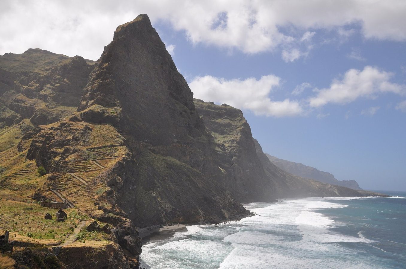
Photo: Konstantin Krismer, CC BY 3.0
| Getting there | Ferry from Mindelo on Sao Vicente to Porto Novo, about 1 h, usually twice a day; no flights |
|---|---|
| Gateway | Mindelo, Sao Vicente |
| Travel time | About 1 h by ferry |
| Days | 3 to 5 nights |
| Best months | Nov–Jun dry and best for hiking; Aug–Oct rainy, green, some paths slippery |
| Getting around | Shared minibuses (aluguers) and taxis; hire a driver for a day, then walk |
| Booking | Ferry tickets in high season and rooms in Ponta do Sol and Paul; guides locally |
| Cost | Cheap, even by Cape Verde standards |
| Beaches | Almost none; rough black pebble shores, a small black-sand beach at Tarrafal de Monte Trigo |
| Sea | Atlantic Ocean |
| Area | 779 km² |
| Population | 38,200 (2019) |
| Highest point | 1,979 m (Topo da Coroa) |
| Ferry | 1 h from Mindelo, Sao Vicente |
| Airport | No |
| Car-free | No |
| Checked | October 2026 |
Two kinds of product are sold for Santo Antão, and both make sense.
The first is the day trip from Mindelo. You take the early ferry to Porto Novo, where a driver and guide meet you, and spend the day crossing the island by the old cobbled mountain road past the Cova crater, looking down into the Paul valley, and following the north coast to Ribeira Grande, Ponta do Sol and the cliff village of Fontainhas, before the late ferry back. Transport, guide and usually lunch are included; the ferry ticket is included in some offers and not others, so check. It shows the scenery but leaves little time to walk, and the day is long.
The second, and better, is walking. Guided day hikes run from the Cova crater down into Paul, along Ribeira da Torre, or on the coastal path from Ponta do Sol through Fontainhas to Cruzinha. Two-day hiking packages and longer trips with nights in village guesthouses cover more ground. Cooking classes, rum distillery visits and lighthouse walks fill a spare afternoon.
Book a guide for the first hike, stay at least three nights and walk downhill: drivers will drop you at the top of a valley.
The greenest valley in Cape Verde runs from the rim of the Cova crater down to the sea at Vila das Pombas. The path descends steeply for about 1,000 metres past terraces of sugar cane, bananas, coffee and yams, with small bars selling grogue, the local cane spirit. Allow three to four hours downhill and arrange a lift at the bottom.
Ponta do Sol is a small fishing town at the northern tip with a harbour where boats are hauled up on the rocks. From there a path cut into the cliff climbs to Fontainhas, a village of coloured houses balanced on a ridge above a gorge, about 45 minutes away. Continue along the coast to Cruzinha for a full day.
The old road from Porto Novo climbs in hairpins, paved with stones laid by hand, to the ridge at well over 1,000 metres. Here the Cova is an extinct crater whose flat floor is farmed in neat fields, and from its rim the land falls away into Paul. Clouds roll over the pass most afternoons, so come in the morning for the view.
Ribeira Grande, the old town on the north coast, is the starting point for the Ribeira da Torre, a deep valley between sheer walls with terraced fields and scattered hamlets. A path climbs up the valley floor towards the mountain villages of Xoxo and the ridge, and taxis in town can take you to its upper end so you can walk down.
The dry western side is a different island: brown slopes below the summit of Topo da Coroa, at 1,979 metres the highest point. A long, rough road reaches the remote village of Tarrafal de Monte Trigo, with a black-sand beach and a few guesthouses. It is a two-hour drive from Porto Novo by four-wheel drive.
Our pick for each kind of trip, with live dates and prices. Free cancellation on most.
Best for: First visit, a day from Mindelo
Ferry and driver in one package: the mountain road over the crater, the Paul valley and the north coast, back on the evening boat.
Santo Antão has an airstrip near Ponta do Sol, but it has been closed for years, so everyone arrives by sea. Ferries cross from Mindelo on Sao Vicente to Porto Novo in about an hour, usually twice a day, early morning and late afternoon, with extra sailings on busy days. Buy tickets at the port in Mindelo, or online in advance in high season. The channel can be rough, so take seasickness pills if you are prone.
Sao Vicente's airport, a short taxi ride from Mindelo, has flights from Lisbon and inter-island flights from Praia and Sal. Cars can travel on the ferry, but hiring a driver on arrival is simpler and cheap.
At Porto Novo, shared minibuses called aluguers wait for every ferry and run over the mountain or round the coast to Ribeira Grande, Ponta do Sol and Paul; they leave when full. Taxis and private drivers can be hired for a day and will drop hikers at the top of valleys. Roads are mostly cobbled and winding, and car hire is rare. Walking is the point of the island: paths are old mule tracks, well used by villagers but steep and unfenced.
Santo Antão can be visited all year, but the best season for walking is November to June, when the weather is dry and sunny on the coast and cooler in the mountains, with daytime temperatures in the mid-twenties. From January to April the harmattan wind can bring dusty haze from the Sahara that hides the views.
The short rainy season, roughly August to October, brings heavy showers to the north, turns the valleys bright green and fills the streams, but some paths become slippery and rock falls block roads for a day. The south and west stay dry all year. Crowds are never a problem, but rooms in Ponta do Sol and Paul are few, so book ahead around Christmas and Easter. Three to five nights allows several valleys.
Ponta do Sol is the main base, with guesthouses, restaurants and easy access to the coastal path and Ribeira Grande. The Paul valley has small lodges and rooms among the terraces and at Vila das Pombas on the coast, ideal for walkers who want to start hikes from the door. Porto Novo is convenient for the ferry but dry and plain. Mountain guesthouses near the Cova crater are cool and quiet, while Tarrafal de Monte Trigo suits those who want isolation.
The island was uninhabited when Portuguese navigators sighted it in the fifteenth century and was settled slowly from the sixteenth, by Portuguese farmers and enslaved Africans brought to work the land. Sugar cane, grogue distilling and subsistence farming on terraces cut into the valleys shaped its villages, while droughts and famines drove waves of emigration to the Americas and Europe. The mule tracks and cobbled roads built by hand are still the island's arteries, and Cape Verde has been independent since 1975.
Santo Antão is almost always paired with Sao Vicente: spend a night or two in Mindelo for its music, cafes and colonial waterfront, an hour away by ferry. From Sao Vicente, flights reach Sal and Boa Vista for beaches, and Santiago for the old capital and its own mountains, making a one-to-two-week tour of the islands.
Ferry from Mindelo on Sao Vicente to Porto Novo, about 1 h, usually twice a day; no flights.
From Mindelo, Sao Vicente: about 1 h by ferry.
3 to 5 nights.
Nov–Jun dry and best for hiking; Aug–Oct rainy, green, some paths slippery.
Shared minibuses (aluguers) and taxis; hire a driver for a day, then walk.
Go if you want serious day hikes through deep green valleys, mountain villages and dramatic ocean cliffs. Skip it or choose Sal or Boa Vista if you want sandy beaches, swimming and resort comforts. With about 1 h each way from Mindelo, Sao Vicente, a day trip is easy to do.
Cheap, even by Cape Verde standards.
Almost none; rough black pebble shores, a small black-sand beach at Tarrafal de Monte Trigo.
Ferry tickets in high season and rooms in Ponta do Sol and Paul; guides locally.
Yes. Boat trips, guided tours and day trips for Santo Antão can be booked online; live prices and free cancellation on most are shown on this page.
Cape Verde Islands, Cape Verde
Boa Vista is the easternmost island of Cape Verde, a flat, desert-like island of about 630 square kilometres only 450…
82 tours & trips
Cape Verde
Sao Vicente is a dry, windswept volcanic island in the northern Cape Verde archipelago, home to Mindelo, the…
37 tours & trips
Cape Verde
Cape Verde is an archipelago of ten volcanic islands in the Atlantic, between 600 and 850 km off the coast of Senegal,…
25 tours & trips
Cape Verde
Sal is a flat, dry island of 215 square kilometres in the Cape Verde archipelago, about 560 km off the coast of West…
24 tours & trips
Cape Verde Islands, Cape Verde
Maio is a flat, dry island of about 275 square kilometres in the south-east of Cape Verde, a short hop from the…
9 tours & trips
Cape Verde Islands, Cape Verde
Fogo is a single volcano rising from the Atlantic in southern Cape Verde, its summit cone reaching 2,829 metres, the…
3 tours & trips