Waiheke Island
New Zealand
Waiheke Island lies in the Hauraki Gulf, about 40 minutes by fast ferry from downtown Auckland, and is the city's…
39 tours & trips
New Zealand · Pacific Ocean · Volcanic island
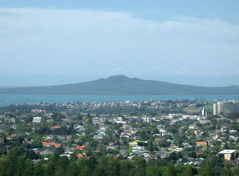
Rangitoto Island is the youngest volcano in the Auckland volcanic field, a symmetrical cone that rose from the Hauraki Gulf only about 600 years ago. A 25-minute ferry ride from downtown Auckland, it has no residents, no shops and no cars, just black lava fields, pohutukawa forest and a summit at 260 metres.
| Getting there | Ferry from Auckland's Downtown Ferry Terminal in about 25 min, a few sailings a day, some via Devonport |
|---|---|
| Gateway | Auckland (Downtown Ferry Terminal) |
| Travel time | 25 min by ferry |
| Days | A day trip is enough |
| Best months | Oct–Apr for walking; Dec–Feb hot and shadeless on the summit track |
| Getting around | Car-free: walk the marked tracks, or join a guided e-bike or road-train tour |
| Booking | Ferry tickets a day or two ahead in summer and at weekends; kayak tours a week ahead |
| Cost | Mid-range; the ferry is the only real cost |
| Beaches | No sandy beaches; rocky lava shores, with swimming at Islington Bay and the wharf |
| Sea | Pacific Ocean |
| Area | 23 km² |
| Population | Uninhabited |
| Highest point | 260 m |
| Ferry | 25 min from Auckland (Downtown Ferry Terminal) |
| Airport | No |
| Car-free | Yes |
| Checked | October 2026 |
Rangitoto is simple to do independently, and most visitors buy nothing more than a return ferry ticket. The ferry gives you about four to six hours on the island depending on the timetable, enough to walk to the summit, see the lava caves and come back for the afternoon boat.
Guided options add context rather than access. Walking tours with a ferry ticket included follow the same track with a guide who explains the eruption, the plants that colonise bare lava and the island's Maori and wartime past. Guided e-bike tours use the gravel service roads to cover Rangitoto and the neighbouring farmland of Motutapu across the causeway, which is far more ground than you could walk in a day. A road-train style tour on the old service road takes less mobile visitors most of the way up, leaving a short boardwalk climb.
The most memorable option is a sea kayak trip: you paddle across from the city's eastern bays in the afternoon, walk to the summit for sunset and paddle back by headtorch. It needs reasonable fitness but no experience.
Our advice: take the ferry, go up the summit track and back via the lava caves, and save a guided tour for Motutapu.
From Rangitoto Wharf a well-made track climbs about 260 metres through lava fields and forest to the summit in roughly an hour. A boardwalk circles the crater rim, densely wooded inside. From the top you see the city skyline, the North Shore, Waiheke and the Hauraki Gulf. Take water: there is none on the island.
A short side track below the summit leads to lava tubes formed when the outer crust of a flow cooled while molten rock drained out from inside. You can walk through the largest, which is about 50 metres long, stooping in places. Bring a torch or phone light and sturdy shoes, as the floor is rough.
Rangitoto holds what is often described as the largest pohutukawa forest in the world, growing straight out of black scoria. In December and January the trees flower crimson. Along the tracks you can see how lichens, mosses and then trees colonise bare rock, a process still under way six centuries after the eruption.
Small holiday cottages, or baches, were built along the shore in the 1920s and 1930s. Most were later removed, but a group near the wharf and at Islington Bay survives, and one has been restored as a little museum open on some weekends. They show how Aucklanders holidayed here before it became a reserve.
A causeway built during the Second World War joins Rangitoto to Motutapu, an older, grassy island of farmland and coastal walks. From Islington Bay you can walk on to Home Bay, which has a campsite. Allow a full day and check ferry times carefully, as Motutapu has its own limited sailings.
Concrete bunkers, an observation post and the remains of a radar station near the top date from the Second World War, when the island guarded the approaches to Auckland harbour. They are a short walk from the crater boardwalk and give an idea of how strategic this cone was for the city's defence.
Our pick for each kind of trip, with live dates and prices. Free cancellation on most.
Best for: First visit, on your own
A return ferry seat from the city is all most people need to climb the summit track and explore the lava caves at their own pace.
Ferries leave from the Downtown Ferry Terminal at the foot of Queen Street and take about 25 minutes to Rangitoto Wharf, some calling at Devonport on the North Shore on the way. There are only a few sailings a day, more at weekends and in summer, and the last return boat leaves mid-afternoon; missing it means an expensive water taxi or an unplanned night outdoors.
Tickets can be bought at the terminal, but book ahead on summer weekends and holidays. Rangitoto is a pest-free reserve, so before boarding you are asked to check shoes and bags for soil, seeds, rodents and insects; clean your boots beforehand.
There is no car access. Leave a car at one of the city parking buildings near the waterfront, or come by train or bus to Britomart, a few minutes' walk from the terminal.
You walk. The main tracks are well marked and graded but rough underfoot, over sharp scoria, so wear proper shoes rather than sandals. The summit is about an hour from the wharf, and the coastal track to Islington Bay takes longer. There are toilets near the wharf and at Islington Bay but no water, food or rubbish bins, so carry everything in and out. Guided e-bike and road-train tours use the service roads where private vehicles are not allowed.
Rangitoto can be visited all year, but conditions on the lava change a lot with the season. October to April brings the longest days and the most sailings. In December, January and February the black rock absorbs heat and the summit track has little shade, so start on the first ferry, carry at least a litre of water each and wear a hat. Late summer and autumn, March and April, are often the most pleasant, with settled weather and warm sea at the wharf.
Winter, June to August, is cooler and wetter, with fewer ferries and short days, but clear days give the sharpest views over the gulf and the island is quiet. Weekends and school holidays are busiest; weekdays outside January are calm. Pohutukawa flower in December and early January. Half a day is enough for the summit and caves; add Motutapu to make a full day.
There is no accommodation on Rangitoto and camping is not allowed, so everyone stays in Auckland. The city centre and the waterfront around the Viaduct are the most convenient, a short walk from the ferry terminal. Devonport, a Victorian seaside suburb on the North Shore with its own ferry, is a quieter base with cafes and two small volcanic cones of its own. Ponsonby suits those who want restaurants and nightlife. Campers can use the site at Home Bay on Motutapu.
Rangitoto rose from the sea in two eruptions around 1450 and 1500, recent enough that Maori living on Motutapu watched it happen; their footprints are preserved in ash there. The name is usually explained as the bloody sky of a wounded chief from the Arawa canoe. The Crown bought the island in 1854 and opened it as a public reserve in 1890. Prisoners built roads and tracks, holiday baches spread along the shore and wartime defences followed. Pests were eradicated in 2009, and native birds have since returned.
Auckland's ferry network makes it easy to combine islands. Waiheke, with vineyards and beaches, is about 40 minutes from the same terminal and fills another day. Devonport is 12 minutes away and pairs well with the morning ferry. Bird lovers can add Tiritiri Matangi, a predator-free sanctuary about 75 minutes away, and the city's other volcanic cones, such as Mount Eden, give a contrasting view back to Rangitoto.
Ferry from Auckland's Downtown Ferry Terminal in about 25 min, a few sailings a day, some via Devonport.
From Auckland (Downtown Ferry Terminal): 25 min by ferry.
A day trip is enough.
Oct–Apr for walking; Dec–Feb hot and shadeless on the summit track.
No. Rangitoto Island is car-free. Car-free: walk the marked tracks, or join a guided e-bike or road-train tour.
Go if you want an easy half-day volcano climb with city and gulf views close to Auckland. Skip it or choose Waiheke if you are after beaches, vineyards, lunch spots and swimming rather than a hot walk over bare lava. With about 25 min each way from Auckland (Downtown Ferry Terminal), a day trip is easy to do.
Mid-range; the ferry is the only real cost.
No sandy beaches; rocky lava shores, with swimming at Islington Bay and the wharf.
Ferry tickets a day or two ahead in summer and at weekends; kayak tours a week ahead.
Yes. Boat trips, guided tours and day trips for Rangitoto Island can be booked online; live prices and free cancellation on most are shown on this page.
New Zealand
Waiheke Island lies in the Hauraki Gulf, about 40 minutes by fast ferry from downtown Auckland, and is the city's…
39 tours & trips
New Zealand
The South Island is the larger of New Zealand's two main islands, about 150,000 square kilometres with only around…
6 tours & trips
New Zealand
The North Island is the smaller but busier of New Zealand's two main islands, home to three quarters of the…
3 tours & trips
New Zealand
Kapiti Island is a predator-free nature reserve 5.6 km off the Kapiti Coast, an hour north of Wellington.
2 tours & trips
New Zealand
Tiritiri Matangi is a 2.2-square-kilometre open bird sanctuary in the Hauraki Gulf, 3.4 km off the Whangaparāoa…
2 tours & trips
New Zealand
Stewart Island, or Rakiura, is New Zealand's third-largest island, lying 30 km across Foveaux Strait from the…
No tours listed