Tenerife
Canary Islands, Spain
Tenerife is the largest of the Canary Islands, 2,034 square kilometres of Atlantic volcano off north-west Africa,…
723 tours & trips
Spain · Atlantic Ocean · Volcanic island
La Palma is the most north-westerly of the Canary Islands, a steep green volcanic island of about 708 square kilometres rising to 2,426 metres at the Roque de los Muchachos. It is built for walkers and stargazers, with a huge crater-like caldera, laurel forests, one of the world's great observatories and the new volcano of 2021.
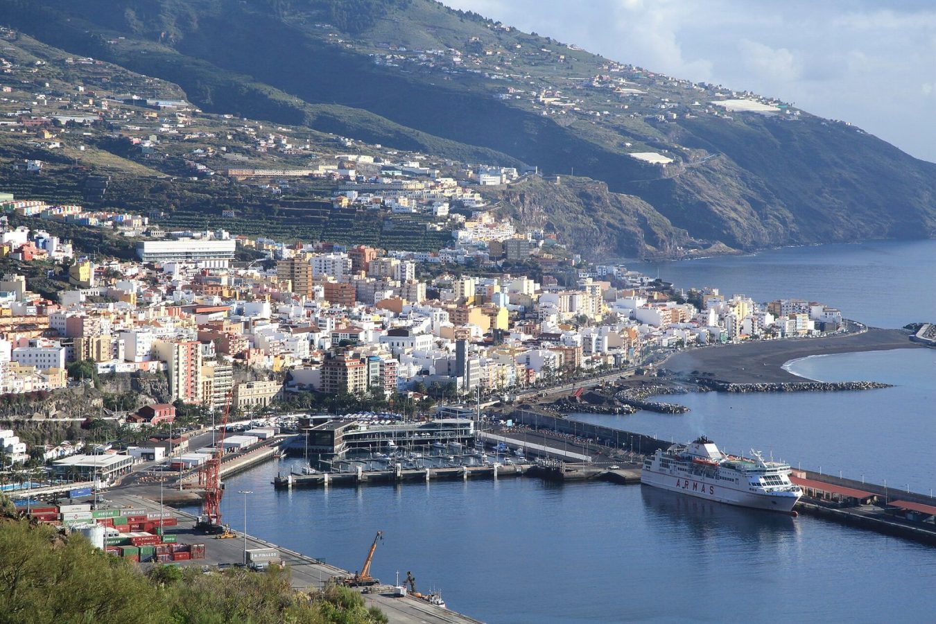
Photo: Frank Vincentz, CC BY-SA 3.0
| Getting there | Flights from Tenerife North, Gran Canaria and mainland Spain, some direct from Europe; ferries from Tenerife about 3 h |
|---|---|
| Gateway | Tenerife (flights or ferry from Los Cristianos) |
| Travel time | 30 min flight from Tenerife North or about 3 h by ferry |
| Days | A week or more |
| Best months | All year mild; Apr–Oct driest for hiking; snow possible on the summit in winter |
| Getting around | Rent a car; buses link the main towns but the roads are long and winding |
| Booking | Car hire early; observatory visits and stargazing a week or two ahead |
| Cost | Mid-range; cheaper than the big Canary resorts |
| Beaches | Black volcanic sand; Los Cancajos near Santa Cruz, Tazacorte and Puerto Naos in the west |
| Sea | Atlantic Ocean |
| Archipelago | Canary Islands |
| Area | 708 km² |
| Population | 86,194 (2025) |
| Highest point | 2,426 m (Roque de los Muchachos) |
| Airport | Yes, scheduled flights |
| Car-free | No |
| Checked | October 2026 |
Most products on La Palma are about walking, volcanoes and the night sky rather than the sea.
The most popular is a guided walk on the 2021 Tajogaite volcano. Access to the lava fields is controlled, and licensed guides take small groups along an official route of a few kilometres past steaming cracks and new cones; sunset versions add a picnic. Other walks go into the Caldera de Taburiente, through the laurel forest of the north-east or along the Route of the Volcanoes in the south. They usually include transport to the trailhead and back, which matters on one-way routes.
Stargazing is the second speciality. Evening sessions with telescopes, some with an astronomer or wine tasting, run at viewpoints across the island, and daytime visits go to the observatory on the summit. Coach and four-wheel-drive tours circle the island in a day, and there are winery visits in the south, lava-tube caving, kayaking and snorkelling off the east coast, and whale and dolphin trips from the harbours.
Guides, transport and equipment are normally included; meals rarely are. Hire a car for the main sights and book a guide for the volcano and a night of stargazing.
The national park at the centre of the island is a vast eroded crater about 8 km across, with walls up to 2,000 metres high and a stream running through pine forest. The viewpoint at La Cumbrecita gives a quick look; the classic day hike follows the gorge of Las Angustias down past the coloured waterfall to Los Llanos.
The eruption of 2021 lasted 85 days and buried houses, roads and banana plantations on the west side. Today you can see the black cone from viewpoints and walk on the lava with a guide, where cracks still release warm gases. The flows created new land where they met the sea below Tazacorte.
A long winding road climbs to the island's summit at 2,426 metres, on the rim of the caldera, where the domes of the international observatory stand above the clouds. The view drops straight into the crater and across to Tenerife's Teide. Bring warm clothes: it can be near freezing even in summer.
The capital, on the east coast, has one of the finest old centres in the Canaries: a cobbled main street with Renaissance churches and town halls, and a seafront lined with houses with carved wooden balconies. A concrete replica of a Columbus ship houses the naval museum. Allow half a day.
The spine of the south is a chain of young cones, walked on a long trail from the Refugio El Pilar to Fuencaliente, about 18 km mostly downhill. At the southern tip, the San Antonio volcano has a visitor centre and the Teneguia cone erupted in 1971. Below are salt pans, a lighthouse and vineyards on volcanic ash.
The wet north-east is covered in laurel forest, a relic of the woods that once covered southern Europe. At Los Tilos a visitor centre marks the start of walks to waterfalls and springs. Nearby, the natural sea pools of Charco Azul at San Andres make a good swim after a forest walk.
Our pick for each kind of trip, with live dates and prices. Free cancellation on most.
Best for: First visit, the 2021 volcano
A walk with a licensed guide on the authorised route across the fresh lava fields and cones of Tajogaite, explaining the eruption and what it destroyed. Most visitors start here.
La Palma airport, on the east coast south of Santa Cruz, has short flights of about 30 minutes from Tenerife North and links to Gran Canaria several times a day, plus flights from Madrid and Barcelona. In winter and summer, charters and scheduled flights come direct from Germany, the Netherlands, the UK and other European countries.
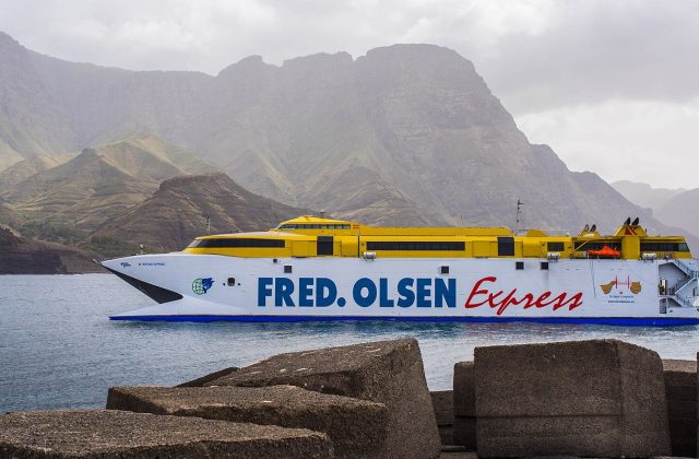
Ferries sail from Los Cristianos in the south of Tenerife to the port of Santa Cruz de La Palma, taking around three hours depending on the boat;Fred. Olsen and Naviera Armas run the routes. Taking a rental car on the ferry is often not allowed, so check the contract or hire a new car on arrival. Cruise ships call at Santa Cruz, mostly in winter.
A car is close to essential. Rental desks are at the airport and in the main towns. Distances look short but the roads twist around ravines; Santa Cruz to Los Llanos takes about 30 minutes through the tunnel under the central ridge, while the north via Barlovento and Garafia is slow. Public buses link the main towns and some trailheads, and taxis help with one-way hikes. Parking is easy except in the centre of Santa Cruz.
La Palma has a mild climate all year, with coastal temperatures from about 18 degrees in winter to the mid-20s in summer and a sea that ranges from about 19 to 23 degrees. The trade winds bring clouds and drizzle to the green east and north, while the west around Los Llanos and Tazacorte is sunnier.
April to October is the driest period and best for high walks, with clear summit views and long days. Winter is greener and suits walkers who escape northern Europe, but rain can close trails and snow occasionally shuts the road to the summit. The almond trees blossom in the north-west in January and February.
The island never feels crowded. The Carnival of Los Indianos in Santa Cruz, when the town dresses in white and throws talcum powder, is a lively time to visit. Plan a week to cover the caldera, the volcanoes and the north.
The island has two sides. Los Llanos de Aridane and Tazacorte in the west are sunnier, closer to the caldera and the 2021 volcano, and suit walkers. Santa Cruz in the east has the old town, the ferry port and easy access to the airport, with beach hotels at Los Cancajos nearby. Rural houses in the north and in the south around Fuencaliente are quiet and good for stargazing, though you need a car.
Before the Spanish arrived, La Palma was home to the Benahoaritas, who left spiral rock carvings that can still be seen at La Zarza in the north. The island was conquered in 1493, and in the 16th century Santa Cruz became one of the busiest ports of the Spanish empire, trading sugar and wine with the Americas. Later, bananas covered the western slopes. Volcanoes have reshaped the island repeatedly, in 1949, 1971 and 2021. Since the 1980s a law protecting the night sky has kept the observatory skies dark.
La Palma pairs well with Tenerife, half an hour away by plane or three hours by ferry, for Teide and the larger resorts. La Gomera, with its laurel forests and walking villages, is a short hop from Tenerife and suits the same visitors. El Hierro, the smallest Canary island, is a quiet extension by plane via Tenerife.
Flights from Tenerife North, Gran Canaria and mainland Spain, some direct from Europe; ferries from Tenerife about 3 h.
From Tenerife (flights or ferry from Los Cristianos): 30 min flight from Tenerife North or about 3 h by ferry.
A week or more.
All year mild; Apr–Oct driest for hiking; snow possible on the summit in winter.
Rent a car; buses link the main towns but the roads are long and winding.
Go if you want serious hiking, volcanic landscapes, dark skies and a quiet, unspoilt Canary island. Skip it or choose Tenerife or Gran Canaria if you want long sandy beaches, big resorts and nightlife.
Mid-range; cheaper than the big Canary resorts.
Black volcanic sand; Los Cancajos near Santa Cruz, Tazacorte and Puerto Naos in the west.
Car hire early; observatory visits and stargazing a week or two ahead.
Yes. Boat trips, guided tours and day trips for La Palma can be booked online; live prices and free cancellation on most are shown on this page.
Canary Islands, Spain
Tenerife is the largest of the Canary Islands, 2,034 square kilometres of Atlantic volcano off north-west Africa,…
723 tours & trips
Canary Islands, Spain
Gran Canaria is a round volcanic island of 1,560 square kilometres in the Canaries, rising from the dunes of Maspalomas…
350 tours & trips
Canary Islands, Spain
Lanzarote is the easternmost of the Canary Islands, about 125 km off the coast of Africa, a low island of black lava…
273 tours & trips
Canary Islands, Spain
Fuerteventura is the second-largest of the Canary Islands and the closest to Africa, about 97 km off the Moroccan…
233 tours & trips
Canary Islands, Spain
Isla de Lobos is an uninhabited volcanic islet of under 5 square kilometres, 2 km off the northern tip of Fuerteventura…
28 tours & trips
Canary Islands, Spain
La Gomera is one of the smallest Canary Islands, a round volcanic island about 22 km across, cut by deep ravines and…
16 tours & trips